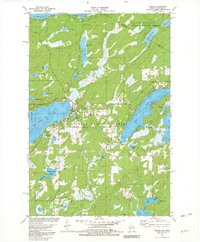
1981 Map of Phelps
USGS Topo · Published 1982About this map
The town of Phelps serves as the central hub of this Northwoods landscape, situated on the eastern shore of North Twin Lake. This 1981 survey documents a region defined by its dense network of glacial lakes and the convergence of two major federal lands: the Nicolet National Forest and the Ottawa National Forest. The historical Military Road winds through the terrain, connecting local settlements and resource hubs near the Wisconsin-Michigan border. Local industry and infrastructure are represented by several Gravel Pits and a lookout tower on Military Hill, reflecting the area's dual focus on timber management and recreation. Large water bodies like Long Lake and Big Sand Lake dominate the eastern half of the map, while numerous smaller basins like Afterglow Lake and Sugar Maple Lake dot the forested interior.
Find a feature on this map
46 named features on this map. Tap any name to fly to it.
Don’t see what you’re looking for? This feature index may not catch every label — zoom into the map to look around manually.
Map Details
Editions of this 1981 Phelps Map
This is the sole edition of this map. No revisions or reprints were ever made.
Other maps of this area

1928 · Three Lakes
USGS Topo · 1:48,000

1938 · Phelps
USGS Topo · 1:48,000

1938 · Alvin
USGS Topo · 1:48,000

1938 · Three Lakes
USGS Topo · 1:48,000

1945 · Three Lakes
USGS Topo · 1:48,000

1946 · Alvin
USGS Topo · 1:48,000

1950 · Phelps
USGS Topo · 1:48,000

1954 · Iron Mountain
USGS Topo · 1:250,000

1956 · Beechwood
USGS Topo · 1:62,500

1956 · Phelps
USGS Topo · 1:62,500