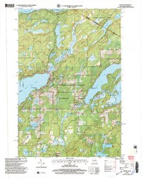
1999 Map of Phelps
USGS Topo · Published 2004About this map
Phelps serves as the primary hub of activity in this lake-dotted landscape along the border of Wisconsin and Michigan's Upper Peninsula. At the turn of the 21st century, the region remains defined by its dense forest cover and expansive water systems, with the massive North Twin Lake and Long Lake dominating the central topography. The map illustrates a high concentration of recreational and conservation infrastructure, from the Public Boat Access points on Spectacle Lake to the protected boundaries of the Chequamegon Nicolet National Forest and the Blackjack Springs Wilderness. Notable local landmarks like Military Hill and its Lookout overlook a network of smaller bodies of water such as Sugar Maple Lake and Afterglow Lake, connected by the winding Deerskin River. This survey captures a moment when the regional economy was firmly centered on both timber management and the seasonal tourism of the northern woods.
Find a feature on this map
45 named features on this map. Tap any name to fly to it.
Don’t see what you’re looking for? This feature index may not catch every label — zoom into the map to look around manually.
Map Details
Editions of this 1999 Phelps Map
This is the sole edition of this map. No revisions or reprints were ever made.
Other maps of this area

1928 · Three Lakes
USGS Topo · 1:48,000

1938 · Phelps
USGS Topo · 1:48,000

1938 · Alvin
USGS Topo · 1:48,000

1938 · Three Lakes
USGS Topo · 1:48,000

1945 · Three Lakes
USGS Topo · 1:48,000

1946 · Alvin
USGS Topo · 1:48,000

1950 · Phelps
USGS Topo · 1:48,000

1954 · Iron Mountain
USGS Topo · 1:250,000

1956 · Beechwood
USGS Topo · 1:62,500

1956 · Phelps
USGS Topo · 1:62,500