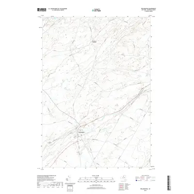
2019 Map of Philadelphia
USGS Topo · Published 2019About this map
The village of Philadelphia serves as a central hub in Jefferson County, positioned where the Indian River meets several local drainage systems like Otter Creek and Halls Cr. This landscape is defined by its agrarian roots and water resources, evidenced by the presence of Childs Falls and the secluded Moon Lake in the northwest corner. The village layout is densely packed along Main ST and Antwerp RD, contrasting with the more dispersed rural layout seen at Bentleys Corners. For genealogists, the map preserves the location of the Quaker Cem near the town center and the Sandy Hollow Cem further south. The proximity to Fort Drum to the southeast marks the transition from civilian farmland to military territory, while the Rivergate Trail offers a modern recreational use for old corridors through the township.
Find a feature on this map
57 named features on this map. Tap any name to fly to it.
Don’t see what you’re looking for? This feature index may not catch every label — zoom into the map to look around manually.
Map Details
Editions of this 2019 Philadelphia Map
This is the sole edition of this map. No revisions or reprints were ever made.
Other maps of this area

1903 · Alexandria Bay
USGS Topo · 1:62,500

1903 · Theresa
USGS Topo · 1:62,500

1911 · Antwerp
USGS Topo · 1:62,500

1912 · Hammond
USGS Topo · 1:62,500

1943 · Redwood
USGS Topo · 1:31,680

1944 · Hammond
USGS Topo · 1:62,500

1948 · Theresa
USGS Topo · 1:24,000
1948 · Black River
USGS Topo · 1:24,000
1948 · Theresa
USGS Topo · 1:62,500

1948 · Alexandria Bay
USGS Topo · 1:62,500