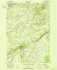
1951 Map of Philadelphia
USGS Topo · Published 1951About this map
The Indian River serves as the primary drainage and geographical anchor for this section of northern New York, where the village of Philadelphia sits at the junction of several rail lines and rural roads. Following a post-war period of agricultural and military importance, the map shows the extensive footprint of the Pine Camp Military Reservation occupying much of the southeastern quadrant. This military presence, defined by the Indian Mil Res Bdy, sits alongside established family-named crossroads like Bishops Corners, Bentleys Corners, and Halls Corners. A network of rural education is visible through several numbered structures, including School No 6 and School No 9, while local heritage is preserved at sites like the Quaker Cemetery and Sandy Hollow Cemetery. The New York Central railroad tracks cut a diagonal path across the landscape, illustrating the importance of rail transit to the local economy and the transport of goods near Moon Lake.
Find a feature on this map
31 named features on this map. Tap any name to fly to it.
Don’t see what you’re looking for? This feature index may not catch every label — zoom into the map to look around manually.
Map Details
Editions of this 1951 Philadelphia Map
This is the sole edition of this map. No revisions or reprints were ever made.
Other maps of this area

1903 · Alexandria Bay
USGS Topo · 1:62,500

1903 · Theresa
USGS Topo · 1:62,500

1911 · Antwerp
USGS Topo · 1:62,500

1912 · Hammond
USGS Topo · 1:62,500

1943 · Redwood
USGS Topo · 1:31,680

1944 · Hammond
USGS Topo · 1:62,500

1948 · Theresa
USGS Topo · 1:24,000
1948 · Black River
USGS Topo · 1:24,000
1948 · Theresa
USGS Topo · 1:62,500

1948 · Alexandria Bay
USGS Topo · 1:62,500