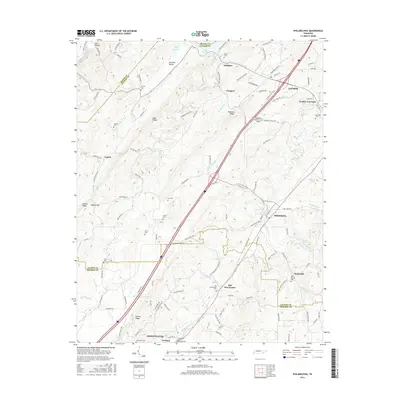
2016 Map of Philadelphia
USGS Topo · Published 2016About this map
Philadelphia and Loudon sit at the center of this Tennessee landscape where the waters of Sweetwater Creek and Pond Creek carve through a series of parallel ridges including Matlock Ridge and Snow Ridge. The map reveals a high concentration of family-named cemeteries such as Lay Cem, Carter Cem, and Marney Cem, indicating deep-rooted multi-generational land ownership across the Stockton Valley and Old Sweetwater areas. An unusual local landmark, the Fergusons Flying Circus Airport, is located just south of Loudon, illustrating the mix of traditional rural life and private aviation. The terrain is marked by significant topographical gaps like Galyon Gap, which historically dictated the paths of travel and communication between these east Tennessee valley communities.
Find a feature on this map
117 named features on this map. Tap any name to fly to it.
Don’t see what you’re looking for? This feature index may not catch every label — zoom into the map to look around manually.
Map Details
Editions of this 2016 Philadelphia Map
This is the sole edition of this map. No revisions or reprints were ever made.
Other maps of this area

1887 · Kingston
USGS Topo · 1:125,000

1891 · Kingston
USGS Topo · 1:125,000

1893 · Kingston
USGS Topo · 1:125,000

1895 · Loudon
USGS Topo · 1:125,000

1935 · Niota
USGS Topo · 1:24,000

1935 · Lenoir City
USGS Topo · 1:24,000

1935 · Philadelphia
USGS Topo · 1:24,000

1936 · Cave Creek
USGS Topo · 1:24,000
1936 · Madisonville
USGS Topo · 1:24,000
1936 · Sweetwater
USGS Topo · 1:24,000