
1953 Map of Philip SE
USGS Topo · Published 1955About this map
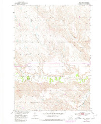
Bad River meanders across the central plains of Haakon County, South Dakota, in this early 1950s survey, illustrating a landscape defined by seasonal watercourses and the infrastructure of the Chicago and North Western railroad. The map documents a sparse, rural settlement pattern typical of the era, where one-room schoolhouses served as local anchors for ranching families. Significant shifts in rural education are evident with several sites already marked as derelict, including the Berry Sch and Kurth Sch. In contrast, the Magnuson Sch remains active north of the tracks. The western edge of the quadrangle is occupied by the Philip Municipal Airport, complete with a Beacon, positioned near the confluence of Grindstone Creek and the river. Numerous named drainages like Belcher Draw and Withburn Creek carve into the tableland, showing the fine-grained topography of this Missouri River Basin region.
Find a feature on this map
16 named features on this map. Tap any name to fly to it.
Don’t see what you’re looking for? This feature index may not catch every label — zoom into the map to look around manually.
Map Details
Editions of this 1953 Philip SE Map
2 editions found
Other maps of this area

1953 · Philip Junction
USGS Topo · 1:24,000

1953 · Philip
USGS Topo · 1:24,000

1954 · Belvidere NW
USGS Topo · 1:24,000

1954 · Kadoka NE
USGS Topo · 1:24,000

1954 · Powell
USGS Topo · 1:24,000

1954 · Pierre
USGS Topo · 1:250,000

1955 · Martin
USGS Topo · 1:250,000

1958 · Pierre
USGS Topo · 1:250,000

1958 · Martin
USGS Topo · 1:250,000

1980 · Kadoka
USGS Topo · 1:100,000