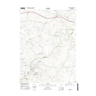
2016 Map of Philipsburg
USGS Topo · Published 2016About this map
Moshannon Creek carves a winding path through the borderlands of Centre and Clearfield counties, anchoring a network of coal-country settlements and historic burial grounds. The primary population center of Philipsburg is flanked by several distinct neighborhoods, including South Philipsburg, North Philipsburg, and Chester Hill, illustrating the dense residential development along the Cold Stream and the railroad corridor at Loch Lomond Junction. To the north, smaller communities like Morrisdale, Winburne, and Kylertown are connected by a web of local roads such as Old Bellefonte Pike and Winburne Rd. Genealogists will find a high concentration of established cemeteries, including Old Cem, New Cem, and Immanuel Cem, reflecting the deep roots of these mining and industrial townships. The landscape is also marked by Emigh Lake and several prominent drainages like Alder Run and One mile Run, which defined the early logistical and economic layout of this region.
Find a feature on this map
136 named features on this map. Tap any name to fly to it.
Don’t see what you’re looking for? This feature index may not catch every label — zoom into the map to look around manually.
Map Details
Editions of this 2016 Philipsburg Map
This is the sole edition of this map. No revisions or reprints were ever made.
Other maps of this area

1903 · Houtzdale
USGS Topo · 1:62,500

1905 · Houtzdale
USGS Topo · 1:62,500

1922 · Philipsburg
USGS Topo · 1:62,500

1929 · Karthaus
USGS Topo · 1:62,500

1929 · Clearfield
USGS Topo · 1:48,000

1932 · Clearfield
USGS Topo · 1:62,500

1932 · Karthaus
USGS Topo · 1:62,500

1939 · Philipsburg
USGS Topo · 1:62,500

1944 · Houtzdale
USGS Topo · 1:24,000

1945 · Philipsburg
USGS Topo · 1:62,500