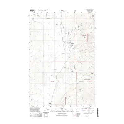
2014 Map of Philipsburg
USGS Topo · Published 2014About this map
Philipsburg serves as the focal point of this Granite County landscape, situated where the Philipsburg Valley meets the rising terrain of the Deerlodge National Forest. The map documents a town defined by its mining heritage and mountain geography, with numerous roads like Algonquin Mine RD and Brewery RD hinting at the industrial history of the gulches. To the south, the settlement of Rumsey sits near Fred Burr Cr, while Porters Corner marks a junction further down the valley. The terrain is marked by prominent elevations such as Red Hill, Duffy Hill, and Franklin Hill, which overlook a network of waterways including Flint Creek and Dirty Dick Cr. Local infrastructure is well-defined, ranging from the Philipsburg Cem to the aviation grounds at Riddick Field, reflecting the contemporary layout of this mountain community.
Find a feature on this map
86 named features on this map. Tap any name to fly to it.
Don’t see what you’re looking for? This feature index may not catch every label — zoom into the map to look around manually.
Map Details
Editions of this 2014 Philipsburg Map
This is the sole edition of this map. No revisions or reprints were ever made.
Other maps of this area

1908 · Philipsburg
USGS Topo · 1:125,000

1947 · Butte
USGS Topo · 1:250,000

1958 · Butte
USGS Topo · 1:250,000

1960 · Butte
USGS Topo · 1:250,000

1962 · Butte
USGS Topo · 1:250,000

1971 · Henderson Mountain
USGS Topo · 1:24,000

1971 · Georgetown Lake
USGS Topo · 1:24,000
1971 · Maxville
USGS Topo · 1:24,000

1971 · Antelope Creek
USGS Topo · 1:24,000

1971 · Potato Lakes
USGS Topo · 1:24,000