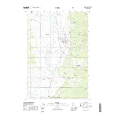
2020 Map of Philipsburg
USGS Topo · Published 2020About this map
The Granite County Courthouse serves as the focal point for the mountain community of Philipsburg, where the residential grid meets the sprawling topography of the Philipsburg Valley. This 2020 record of the landscape illustrates the complex water management system required for both mining and agriculture, evidenced by the Marshall Cr Canal and the winding course of Flint Creek. To the east, the terrain rises sharply toward Rumsey Mtn and the site of Rumsey, a location deeply tied to the region’s silver-mining history. The map detail extends to local landmarks such as Riddick Field and the Philipsburg Cem, while the southern reaches show the intersection at Porters Corner. Significant natural features like Fred Burr Cr and the heights of Franklin Hill define the borderlands of the Deerlodge National Forest, where gulches and hills remain primary geographic markers.
Find a feature on this map
72 named features on this map. Tap any name to fly to it.
Don’t see what you’re looking for? This feature index may not catch every label — zoom into the map to look around manually.
Map Details
Editions of this 2020 Philipsburg Map
This is the sole edition of this map. No revisions or reprints were ever made.
Other maps of this area

1908 · Philipsburg
USGS Topo · 1:125,000

1947 · Butte
USGS Topo · 1:250,000

1958 · Butte
USGS Topo · 1:250,000

1960 · Butte
USGS Topo · 1:250,000

1962 · Butte
USGS Topo · 1:250,000

1971 · Henderson Mountain
USGS Topo · 1:24,000

1971 · Georgetown Lake
USGS Topo · 1:24,000
1971 · Maxville
USGS Topo · 1:24,000

1971 · Antelope Creek
USGS Topo · 1:24,000

1971 · Potato Lakes
USGS Topo · 1:24,000