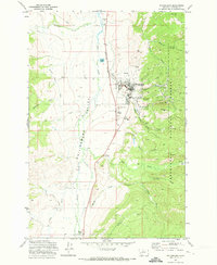
1971 Map of Philipsburg
USGS Topo · Published 1973About this map
Philipsburg sits at the foot of the hills where the Philipsburg Valley meets the eastern mountains in the early 1970s. The landscape is a study in industrial and natural transitions, defined by the Burlington Northern railroad corridor and the extensive mining operations bordering the Deerlodge National Forest. To the east of the town center, a concentration of mines, prospects, and a Strip Mine trace the mineral-rich slopes, with significant tailings deposits near Douglas Creek.
Find a feature on this map
42 named features on this map. Tap any name to fly to it.
Don’t see what you’re looking for? This feature index may not catch every label — zoom into the map to look around manually.
Map Details
Editions of this 1971 Philipsburg Map
This is the sole edition of this map. No revisions or reprints were ever made.
Other maps of this area

1908 · Philipsburg
USGS Topo · 1:125,000

1947 · Butte
USGS Topo · 1:250,000

1958 · Butte
USGS Topo · 1:250,000

1960 · Butte
USGS Topo · 1:250,000

1962 · Butte
USGS Topo · 1:250,000

1971 · Henderson Mountain
USGS Topo · 1:24,000

1971 · Georgetown Lake
USGS Topo · 1:24,000
1971 · Maxville
USGS Topo · 1:24,000

1971 · Antelope Creek
USGS Topo · 1:24,000

1971 · Potato Lakes
USGS Topo · 1:24,000