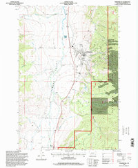
1996 Map of Philipsburg
USGS Topo · Published 1998About this map
Philipsburg occupies a central position in the Philipsburg Valley, serving as a hub for the surrounding mining and ranching landscape. The map reveals an intricate history of resource extraction, with numerous mines, prospects, and a strip mine concentrated on the eastern slopes of the Deerlodge National Forest. Significant industrial land use is evident through features like the Tailings Ponds and the Sewage Disposal Ponds along Flint Creek.
Find a feature on this map
37 named features on this map. Tap any name to fly to it.
Don’t see what you’re looking for? This feature index may not catch every label — zoom into the map to look around manually.
Map Details
Editions of this 1996 Philipsburg Map
This is the sole edition of this map. No revisions or reprints were ever made.
Other maps of this area

1908 · Philipsburg
USGS Topo · 1:125,000

1947 · Butte
USGS Topo · 1:250,000

1958 · Butte
USGS Topo · 1:250,000

1960 · Butte
USGS Topo · 1:250,000

1962 · Butte
USGS Topo · 1:250,000

1971 · Henderson Mountain
USGS Topo · 1:24,000

1971 · Georgetown Lake
USGS Topo · 1:24,000
1971 · Maxville
USGS Topo · 1:24,000

1971 · Antelope Creek
USGS Topo · 1:24,000

1971 · Potato Lakes
USGS Topo · 1:24,000