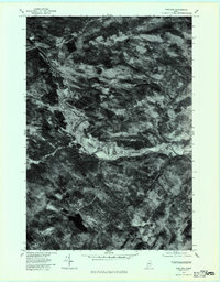
1977 Map of Phillips
USGS Topo · Published 1983About this map
The Sandy River snakes through this Franklin County landscape, its wide, sediment-filled valley providing a stark contrast to the surrounding forested uplands. In the late 1970s, the town of Phillips served as a key local hub where the river bends sharply, marking a transition from the higher peaks of Phillips Mountain to the rolling agricultural and timber lands of Avon. This orthophotoquad captures the physical reality of the terrain in 1977, showing the intricate relationship between human settlement and the river's path, particularly at Avon Corner. To the south, the deep waters of Mount Blue Pond sit tucked beneath the shoulder of Mount Blue, demonstrating the variety of water features from high-elevation brooks like Bear Brook to the broad alluvial plain of the main river valley.
Find a feature on this map
9 named features on this map. Tap any name to fly to it.
Don’t see what you’re looking for? This feature index may not catch every label — zoom into the map to look around manually.
Map Details
Editions of this 1977 Phillips Map
This is the sole edition of this map. No revisions or reprints were ever made.
Other maps of this area

1924 · Farmington
USGS Topo · 1:62,500

1926 · Dixfield
USGS Topo · 1:62,500

1929 · Phillips
USGS Topo · 1:48,000

1929 · Dixfield
USGS Topo · 1:62,500

1930 · Kingfield
USGS Topo · 1:48,000

1932 · Phillips
USGS Topo · 1:62,500

1932 · Kingfield
USGS Topo · 1:62,500

1950 · Lewiston
USGS Topo · 1:250,000

1956 · Dixfield
USGS Topo · 1:48,000

1956 · Farmington
USGS Topo · 1:62,500