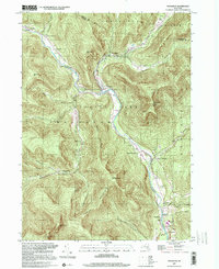
1997 Map of Phoenicia
USGS Topo · Published 2001About this map
Esopus Creek carves a central path through this section of Catskill Park, where the hamlets of Phoenicia and Mount Tremper serve as historically significant nodes of settlement. The landscape is defined by its deep valleys and high summits, including Romer Mountain and Wittenberg Mtn. Traces of the region's industrial and transportation history are evident in the Old Railroad grade and the Ski Lift located near the confluence of the creek and Woodland Valley Creek. Local genealogy and community history are anchored by several burial grounds and religious sites, such as the Shandaken Rural Cem, Longyear Cem, and Our Lady of Good Counsel Ch. The map reveals a settlement pattern dictated by the terrain, with small clusters like Allaben and Chichester tucked into the narrow hollows and creek beds.
Find a feature on this map
50 named features on this map. Tap any name to fly to it.
Don’t see what you’re looking for? This feature index may not catch every label — zoom into the map to look around manually.
Map Details
Editions of this 1997 Phoenicia Map
This is the sole edition of this map. No revisions or reprints were ever made.
Other maps of this area

1892 · Kaaterskill
USGS Topo · 1:62,500

1893 · Kaaterskill
USGS Topo · 1:62,500

1894 · Kaaterskill
USGS Topo · 1:62,500

1899 · Kaaterskill
USGS Topo · 1:62,500

1900 · Phoenicia
USGS Topo · 1:62,500

1901 · Rosendale
USGS Topo · 1:62,500

1903 · Rosendale
USGS Topo · 1:62,500

1903 · Phoenicia
USGS Topo · 1:62,500

1903 · Kaaterskill
USGS Topo · 1:62,500

1903 · Slide Mountain
USGS Topo · 1:62,500