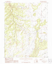
1987 Map of Photograph Gap
USGS Topo · Published 1987About this map
Photograph Gap and the surrounding high desert plateau are meticulously documented in this 1980s provisional survey of San Juan County. The landscape is defined by its drainage systems and vertical relief, ranging from the prominent plateau of Harts Point in the west to the deeply carved Hog Canyon and Turner Water Canyon in the south. The mapping reflects a region where water sources are vital yet scarce, evidenced by the primary Harts Spring and the aptly named The Seeps near the center of the sheet. To the east, the terrain opens into the broad Dry Valley Draw and Dry Valley, while Peters Point Ridge provides a distinct overlook in the southeast corner. This edition captures the area's network of improved and unimproved roads as they existed just before the turn of the 21st century, serving as a record of access points through this complex topography of draws and canyons.
Find a feature on this map
12 named features on this map. Tap any name to fly to it.
Don’t see what you’re looking for? This feature index may not catch every label — zoom into the map to look around manually.
Map Details
Editions of this 1987 Photograph Gap Map
This is the sole edition of this map. No revisions or reprints were ever made.
Other maps of this area

1885 · La Sal
USGS Topo · 1:250,000

1886 · Abajo
USGS Topo · 1:250,000

1892 · Abajo
USGS Topo · 1:250,000

1893 · Abajo
USGS Topo · 1:250,000

1935 · Elk Ridge
USGS Topo · 1:96,000

1940 · Elk Ridge
USGS Topo · 1:125,000

1954 · Elk Ridge 1 NE
USGS Topo · 1:24,000

1954 · Mt Peale 3 NW
USGS Topo · 1:24,000

1954 · Mt Peale 3 SW
USGS Topo · 1:24,000

1954 · Mt Peale 3 NE
USGS Topo · 1:24,000