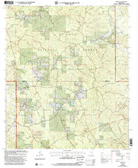
2000 Map of Piave
USGS Topo · Published 2002About this map
The settlement of Piave and the community of Smithtown anchor this region of southeast Mississippi, located along the border of Wayne Co and Greene Co. The landscape is dominated by the sprawling tracts of the De Soto National Forest, which includes the Chickasawhay State Wildlife Management Area and Mason Creek State Wildlife Management Area. These protected lands are defined by an intricate network of waterways, including Mason Creek, Turkey Fork, and the curiously named Hell Hole Creek. Cultural landmarks are scattered throughout the forest, such as Bethel Ch, West Salem Ch, and the Henderson Cem. These features, along with a Gravel Pit near Little Creek, reveal the rural character and land-use patterns of this corner of the state as it appeared at the turn of the 21st century.
Find a feature on this map
23 named features on this map. Tap any name to fly to it.
Don’t see what you’re looking for? This feature index may not catch every label — zoom into the map to look around manually.
Map Details
Editions of this 2000 Piave Map
This is the sole edition of this map. No revisions or reprints were ever made.
Other maps of this area

1953 · Hattiesburg
USGS Topo · 1:250,000

1958 · Hattiesburg
USGS Topo · 1:250,000

1963 · Brewer
USGS Topo · 1:24,000

1964 · Knobtown
USGS Topo · 1:24,000

1964 · Clark
USGS Topo · 1:24,000

1964 · Clara
USGS Topo · 1:24,000

1964 · Mulberry
USGS Topo · 1:24,000

1964 · Buckatunna
USGS Topo · 1:24,000

1964 · Avera
USGS Topo · 1:24,000

1964 · Piave
USGS Topo · 1:24,000