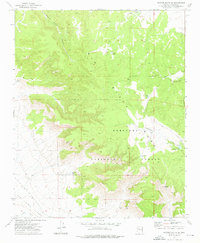
1973 Map of Picacho Butte SE
USGS Topo · Published 1976About this map
Prescott National Forest dominates this mid-1970s landscape, where the high-altitude terrain of Black Mesa transitions into the expansive Big Chino Valley. This area is defined by its rugged water-management infrastructure and historic transport corridors. Ranchers and early settlers utilized a series of catchments such as Mexican Tank and Fritsche Tank to sustain livestock in this arid environment. The presence of an Old Railroad Grade and an Old Railroad Gr indicates the legacy of former rail operations that once bypassed Butcher Knife Canyon. Evidence of small-scale mineral extraction remains at the Storm Seep Mine and Pool Seep Mine, located near the southern edge of the survey where the topography drops toward the Chino Wash.
Find a feature on this map
20 named features on this map. Tap any name to fly to it.
Don’t see what you’re looking for? This feature index may not catch every label — zoom into the map to look around manually.
Map Details
Editions of this 1973 Picacho Butte SE Map
This is the sole edition of this map. No revisions or reprints were ever made.
Other maps of this area

1886 · Chino
USGS Topo · 1:250,000

1887 · Prescott
USGS Topo · 1:250,000

1891 · Chino
USGS Topo · 1:250,000

1892 · Prescott
USGS Topo · 1:250,000

1905 · Jerome
USGS Topo · 1:125,000

1922 · Williams
USGS Topo · 1:125,000

1947 · Ash Fork
USGS Topo · 1:62,500

1947 · Simmons
USGS Topo · 1:62,500

1947 · Picacho Butte
USGS Topo · 1:62,500

1947 · Paulden
USGS Topo · 1:62,500