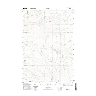
2017 Map of Pickford SE
USGS Topo · Published 2017About this map
Cedarville anchor the southern edge of this landscape where the Upper Peninsula's woodland gives way to a network of creeks and small inland lakes. Moving north through the forested terrain, the map reveals a remote geography defined by drainage systems like Rapson Cr and the E Br Munuscong River. The presence of Hannah Cem near the eastern boundary and the small settlement of Rockview to the west suggests the scattered nature of local homesteads and crossroads. Transportation is largely defined by a grid of named section-line roads, such as E Northwoods Rd and W Flower Creek Rd, which provide access to timber tracts and isolated properties. The inclusion of Quarry Rd hints at the local industrial utility found within the limestone-rich geology of Mackinac County. Water features are central to the terrain, from the marshy edges of Mud Lake and Leach Lake to the winding paths of Flowers Cr and Prentiss Cr.
Find a feature on this map
42 named features on this map. Tap any name to fly to it.
Don’t see what you’re looking for? This feature index may not catch every label — zoom into the map to look around manually.
Map Details
Editions of this 2017 Pickford SE Map
This is the sole edition of this map. No revisions or reprints were ever made.
Other maps of this area

1931 · Pickford SE
USGS Topo · 1:31,680

1953 · Munuscong
USGS Topo · 1:24,000

1953 · Pickford NW
USGS Topo · 1:24,000
1953 · Pickford
USGS Topo · 1:24,000

1954 · Sault Sainte Marie
USGS Topo · 1:250,000

1955 · Cheboygan
USGS Topo · 1:250,000

1956 · Sault Sainte Marie
USGS Topo · 1:250,000

1957 · Sault Sainte Marie
USGS Topo · 1:250,000

1958 · Cheboygan
USGS Topo · 1:250,000

1958 · Sault Sainte Marie
USGS Topo · 1:250,000