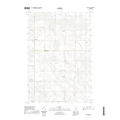
2019 Map of Pickford SE
USGS Topo · Published 2019About this map
Cedarville anchors the southern edge of this landscape where the Eastern Upper Peninsula meets the shoreline of Lake Huron. This 2019 survey captures the rural boundary between Chippewa and Mackinac Counties, a region defined by extensive wetlands and a network of small creeks including Rapson Cr, McKay Cr, and Flowers Cr. The settlement of Rockview sits along Meridian Rd, marking the primary north-south corridor through these timberlands and wetlands.
Find a feature on this map
40 named features on this map. Tap any name to fly to it.
Don’t see what you’re looking for? This feature index may not catch every label — zoom into the map to look around manually.
Map Details
Editions of this 2019 Pickford SE Map
This is the sole edition of this map. No revisions or reprints were ever made.
Other maps of this area

1931 · Pickford SE
USGS Topo · 1:31,680

1953 · Munuscong
USGS Topo · 1:24,000

1953 · Pickford NW
USGS Topo · 1:24,000
1953 · Pickford
USGS Topo · 1:24,000

1954 · Sault Sainte Marie
USGS Topo · 1:250,000

1955 · Cheboygan
USGS Topo · 1:250,000

1956 · Sault Sainte Marie
USGS Topo · 1:250,000

1957 · Sault Sainte Marie
USGS Topo · 1:250,000

1958 · Cheboygan
USGS Topo · 1:250,000

1958 · Sault Sainte Marie
USGS Topo · 1:250,000