1980 Map of Pidgeon Spring SE
USGS Topo · Published 1980About this map
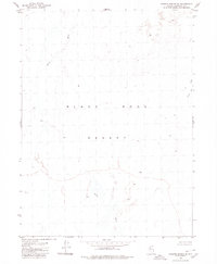
The Black Rock Desert dominates this 1980 survey, revealing a landscape of extreme drainage patterns and alkaline flats in Humboldt County. The most prominent hydrological feature is the Quinn River, which winds across the arid basin floor, its course marked by subtle elevation changes across the playa. This map provides a technical look at the desert's ephemeral water systems, including the Jackson Creek Slough in the northeastern portion of the quadrangle. Photogrammetric methods capture the precise topography of this desert sink, illustrating how water moves—or vanishes—within the terminal basin of northwestern Nevada. It is a study in isolation, where natural terrain features define the entire map area in the absence of roads or permanent human settlements.
Find a feature on this map
3 named features on this map. Tap any name to fly to it.
Don’t see what you’re looking for? This feature index may not catch every label — zoom into the map to look around manually.
Map Details
Editions of this 1980 Pidgeon Spring SE Map
This is the sole edition of this map. No revisions or reprints were ever made.
Other maps of this area

1886 · Disaster
USGS Topo · 1:250,000

1893 · Disaster
USGS Topo · 1:250,000

1931 · Lovelock
USGS Topo · 1:250,000

1935 · Lovelock
USGS Topo · 1:250,000

1954 · Vya
USGS Topo · 1:250,000

1955 · Lovelock
USGS Topo · 1:250,000

1958 · Vya
USGS Topo · 1:250,000

1959 · Lovelock
USGS Topo · 1:250,000

1962 · Vya
USGS Topo · 1:250,000
1966 · King Lear Peak
USGS Topo · 1:62,500