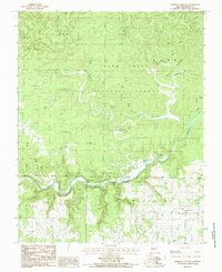
1984 Map of Piedmont Hollow
USGS Topo · Published 1985About this map
Eleven Point National Scenic River winds through this heavily forested portion of the Mark Twain National Forest, carving a deep valley defined by limestone bluffs and numerous cold-water springs. The terrain is characterized by a dense network of hollows, such as Piedmont Hollow and Mine Hollow, which feed into the main river corridor. High points like George Ridge and Backbone Ridge overlook the valley, while karst features like Black Pond and Tupelo Gum Pond punctuate the uplands. Settlement is sparse, focused on small family and community landmarks including Church of Christ and several burial grounds. The presence of Spring Creek Cem, Hickory Grove Cem, and Macedonia Cem indicates long-standing rural communities rooted in the river's bends. This 1980s landscape remains largely defined by the conservation of its water resources, from Roaring Spring to the prominent Cane Bluff river overlook.
Find a feature on this map
47 named features on this map. Tap any name to fly to it.
Don’t see what you’re looking for? This feature index may not catch every label — zoom into the map to look around manually.
Map Details
Editions of this 1984 Piedmont Hollow Map
This is the sole edition of this map. No revisions or reprints were ever made.
Other maps of this area

1931 · Bandyville
USGS Topo · 1:48,000

1943 · Thayer
USGS Topo · 1:62,500

1944 · Couch
USGS Topo · 1:62,500

1944 · Birch Tree
USGS Topo · 1:62,500

1945 · Montier
USGS Topo · 1:62,500

1946 · Thayer
USGS Topo · 1:62,500

1946 · Couch
USGS Topo · 1:62,500

1948 · Montier
USGS Topo · 1:62,500

1948 · Birch Tree
USGS Topo · 1:62,500

1957 · Poplar Bluff
USGS Topo · 1:250,000