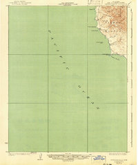
1927 Map of Piedras Blancas
USGS Topo · Published 1941About this map
Point Piedras Blancas serves as the dominant coastal landmark in this 1917 survey of the San Luis Obispo coastline. The shoreline is defined by steep bluffs and several notable offshore formations, including La Cruz Rock and the curiously named Harlech Castle Rock. Inland, the terrain rises sharply toward Pine Top Mtn and Yellow Hill, cut by numerous drainage systems such as Arroyo la Cruz and Arroyo de los Chinos. The presence of the Washington School and the L H (lighthouse) at the point suggests a small but established coastal community and maritime station during the early twentieth century. This map captures the region before modern highway development, showing a landscape defined by its rugged proximity to the Pacific Ocean and the sprawling Piedra Blanca lands.
Find a feature on this map
17 named features on this map. Tap any name to fly to it.
Don’t see what you’re looking for? This feature index may not catch every label — zoom into the map to look around manually.
Map Details
Editions of this 1927 Piedras Blancas Map
2 editions found
Other maps of this area

1919 · Bryson
USGS Topo · 1:62,500

1919 · Piedras Blancas
USGS Topo · 1:62,500

1919 · San Simeon
USGS Topo · 1:62,500

1921 · Cape San Martin
USGS Topo · 1:62,500

1927 · Piedras Blancas
USGS Topo · 1:62,500

1937 · San Simeon
USGS Topo · 1:62,500

1941 · Cape San Martin
USGS Topo · 1:62,500

1941 · Bryson
USGS Topo · 1:62,500

1942 · Bryson
USGS Topo · 1:62,500

1942 · Cape San Martin
USGS Topo · 1:62,500