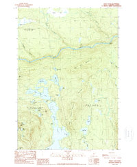
1989 Map of Pierce Pond
USGS Topo · Published 1989About this map
Dead River carves a dominant path through this portion of Somerset County, characterized by a series of significant lakes and high peaks. The interconnected waters of Pierce Pond, joined by The Thoroughfare and reaching south into Otter Pond, define the central geography of the quadrangle. This area, largely managed within the Bowtown and Pierce Pond townships, shows a landscape where water and elevation dictate all movement. Notable peaks like Hurricane Mtn and Black Nubble overlook the valley, while the river's descent is marked by Poplar Hill Falls. The map records a wilderness-oriented terrain with specific points of interest for those tracking regional history or geography, such as the Caribou Narrows and the remote Johnson Bog at the northern boundary.
Find a feature on this map
43 named features on this map. Tap any name to fly to it.
Don’t see what you’re looking for? This feature index may not catch every label — zoom into the map to look around manually.
Map Details
Editions of this 1989 Pierce Pond Map
2 editions found
Other maps of this area

1903 · Bingham
USGS Topo · 1:62,500

1905 · Bingham
USGS Topo · 1:62,500

1905 · The Forks
USGS Topo · 1:62,500

1907 · The Forks
USGS Topo · 1:62,500

1925 · Pierce Pond
USGS Topo · 1:48,000

1927 · Pierce Pond
USGS Topo · 1:62,500

1928 · Dead River
USGS Topo · 1:62,500

1931 · Dead River
USGS Topo · 1:48,000

1944 · Dead River
USGS Topo · 1:62,500

1944 · Pierce Pond
USGS Topo · 1:62,500
Featured Places
- West Forks, ME
- Bowtown Township, ME
- Pierce Pond Township, ME
- Lower Enchanted Township, ME
- Somerset County, ME