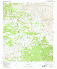
1981 Map of Piety Hill
USGS Topo · Published 1981About this map
Coronado National Forest defines the topography of this high-elevation landscape, where the northern reaches of the Rincon Mountains meet an intricate network of desert canyons and springs. Settlement is sparse, characterized by ranching operations such as Youtcy Ranch and several corral sites connected by the winding Redington Road. The reliance on water management in this arid environment is evident through the high density of named tanks and springs, including Race Track Tank, Bullock Corrals Spring, and the curiously named The Lake. Significant landmarks like Piety Hill and Chimney Rock serve as natural navigational points for those traversing the rugged terrain between Youtcy Canyon and Chimney Rock Canyon. While primarily a ranching and conservation area, scattered Mine symbols and Prospects suggest the history of mineral exploration that often followed early mountain settlers.
Find a feature on this map
49 named features on this map. Tap any name to fly to it.
Don’t see what you’re looking for? This feature index may not catch every label — zoom into the map to look around manually.
Map Details
Editions of this 1981 Piety Hill Map
2 editions found
Other maps of this area

1904 · Tucson
USGS Topo · 1:125,000

1905 · Tucson
USGS Topo · 1:125,000

1945 · Redington
USGS Topo · 1:62,500

1945 · Happy Valley
USGS Topo · 1:62,500

1956 · Tucson
USGS Topo · 1:250,000

1957 · Bellota Ranch
USGS Topo · 1:62,500

1957 · Rincon Valley
USGS Topo · 1:62,500

1957 · Redington
USGS Topo · 1:62,500

1958 · Tucson
USGS Topo · 1:250,000

1958 · Happy Valley
USGS Topo · 1:62,500