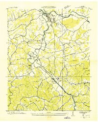
1935 Map of Pigeon Forge
USGS Topo · Published 1935About this map
Sevierville and the nascent village of Pigeon Forge serve as the primary hubs in this mid-1930s landscape, where the Little Pigeon River and its West Fork dictate the flow of local commerce and travel. The presence of the Tennessee Public Service Company Power Plant and an extensive Transmission Line highlights the early electrification efforts by the Tennessee Valley Authority in East Tennessee.
Find a feature on this map
63 named features on this map. Tap any name to fly to it.
Don’t see what you’re looking for? This feature index may not catch every label — zoom into the map to look around manually.
Map Details
Editions of this 1935 Pigeon Forge Map
This is the sole edition of this map. No revisions or reprints were ever made.
Other maps of this area

1886 · Knoxville
USGS Topo · 1:125,000

1892 · Knoxville
USGS Topo · 1:125,000

1893 · Mt Guyot
USGS Topo · 1:125,000

1894 · Knoxville
USGS Topo · 1:125,000

1895 · Knoxville
USGS Topo · 1:125,000

1901 · Knoxville
USGS Topo · 1:125,000

1912 · Mt Guyot
USGS Topo · 1:125,000

1935 · English Mountain
USGS Topo · 1:48,000

1935 · Walden Creek
USGS Topo · 1:24,000

1935 · Richardson Cove
USGS Topo · 1:24,000