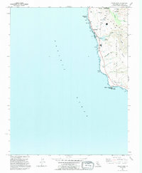
1991 Map of Pigeon Point
USGS Topo · Published 1995About this map
The Pigeon Point Light Station anchors this coastal survey, marking a critical navigational point on the San Mateo shoreline during the early 1990s. The landscape is defined by its series of distinct headlands, including Pescadero Point, Bolsa Point, and the expansive Punta Del Año Nuevo. Inland from the Pacific Ocean, the terrain rises toward The Mesa, dissected by drainages such as Spring Bridge Gulch and Yankee Jim Gulch.
Find a feature on this map
21 named features on this map. Tap any name to fly to it.
Don’t see what you’re looking for? This feature index may not catch every label — zoom into the map to look around manually.
Map Details
Editions of this 1991 Pigeon Point Map
This is the sole edition of this map. No revisions or reprints were ever made.
Other maps of this area

1902 · Santa Cruz
USGS Topo · 1:125,000

1940 · Halfmoon Bay
USGS Topo · 1:62,500

1940 · Ano Nuevo
USGS Topo · 1:62,500

1941 · Ano Nuevo Pt.
USGS Topo · 1:62,500

1942 · Ano Nuevo
USGS Topo · 1:62,500

1943 · Halfmoon Bay
USGS Topo · 1:62,500

1947 · San Francisco
USGS Topo · 1:250,000

1948 · San Francisco
USGS Topo · 1:250,000

1948 · Ano Nuevo
USGS Topo · 1:62,500

1955 · San Francisco
USGS Topo · 1:250,000