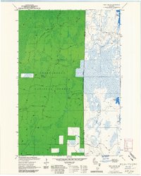
1971 Map of Pike Lake SE
USGS Topo · Published 1985About this map
Chequamegon National Forest dominates this northern Wisconsin landscape, split by the boundary between Price and Oneida counties. The area is defined by its extensive wetlands and groundwater resources, including numerous named seeps such as Foulds Springs, Willow Springs, Grant Spring, and Sieverson Spring. These springs feed a network of waterways including Foulds Creek and Sieverson Creek, which navigate through dense forest and swamp. Managed as part of the Park Falls Ranger District, the terrain reflects the active management of the mid-20th century. High points are utilized for fire surveillance at the Elk River Lookout, while local industry is represented by a small Gravel Pit. To the east, the geography transitions into a cluster of glacial water bodies, most notably Squaw Lake, Bootjack Lake, and the distinctly numbered Lake Sixteen.
Find a feature on this map
17 named features on this map. Tap any name to fly to it.
Don’t see what you’re looking for? This feature index may not catch every label — zoom into the map to look around manually.
Map Details
Editions of this 1971 Pike Lake SE Map
2 editions found
Other maps of this area

1938 · Lac Du Flambeau
USGS Topo · 1:48,000

1939 · Lac Du Flambeau
USGS Topo · 1:48,000

1939 · Mc Cord
USGS Topo · 1:48,000

1941 · Pike Lake
USGS Topo · 1:48,000

1941 · Brantwood
USGS Topo · 1:48,000

1942 · Pike Lake
USGS Topo · 1:48,000

1943 · Brantwood
USGS Topo · 1:48,000

1946 · Lac Du Flambeau
USGS Topo · 1:48,000

1947 · Mc Cord
USGS Topo · 1:48,000

1950 · Pike Lake
USGS Topo · 1:48,000