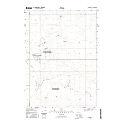
2017 Map of Pillar Butte
USGS Topo · Published 2017About this map
Craters of the Moon National Monument defines the character of this Idaho landscape, where the volcanic geology of the Wapi Flow creates a stark, intricate terrain. The survey highlights significant geological formations including the Great Rift and the massive depression of the Kings Bowl. In this part of Blaine Co, the labels reveal a history of evocative naming for the volcanic features, from the treacherous-sounding Inferno Chasm and Cottrells Blowout to the ironically named The Frying Pan. The southern reaches of the map are anchored by Pillar Butte and the grassy island of Wapi Park, illustrating how these basalt fields were mapped and understood by researchers and public land managers in the early twenty-first century.
Find a feature on this map
14 named features on this map. Tap any name to fly to it.
Don’t see what you’re looking for? This feature index may not catch every label — zoom into the map to look around manually.
Map Details
Editions of this 2017 Pillar Butte Map
This is the sole edition of this map. No revisions or reprints were ever made.
Other maps of this area

1954 · Pocatello
USGS Topo · 1:250,000

1955 · Idaho Falls
USGS Topo · 1:250,000

1958 · Idaho Falls
USGS Topo · 1:250,000

1958 · Pocatello
USGS Topo · 1:250,000

1972 · Schodde Well
USGS Topo · 1:24,000
1972 · Rattlesnake Butte
USGS Topo · 1:24,000

1972 · Bear Trap Cave
USGS Topo · 1:24,000

1972 · Mule Butte
USGS Topo · 1:24,000
1972 · Pillar Butte SE
USGS Topo · 1:24,000

1972 · Mosby Well
USGS Topo · 1:24,000