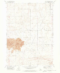
1972 Map of Pillar Butte SE
USGS Topo · Published 1976About this map
Wapi Flow dominates the southwestern quadrant of this 1970s survey, marking a stark geological boundary against the agricultural developments of Pleasant Valley. This transition between the dark volcanic terrain and the surrounding plains is defined by a rigorous grid of section lines and water management infrastructure, indicated by dozens of individually plotted wells that support local ranching or farming. The map captures the boundary between Bingham Co and Power Co, illustrating a rural landscape where essential utility nodes like a Substation and Radio Tower serve a sparse but organized population.
Find a feature on this map
11 named features on this map. Tap any name to fly to it.
Don’t see what you’re looking for? This feature index may not catch every label — zoom into the map to look around manually.
Map Details
Editions of this 1972 Pillar Butte SE Map
This is the sole edition of this map. No revisions or reprints were ever made.
Other maps of this area

1934 · American Falls
USGS Topo · 1:62,500

1934 · Rockland
USGS Topo · 1:62,500

1936 · American Falls
USGS Topo · 1:62,500

1937 · Rockland
USGS Topo · 1:62,500

1954 · Pocatello
USGS Topo · 1:250,000

1958 · Pocatello
USGS Topo · 1:250,000

1959 · Yale
USGS Topo · 1:62,500
1971 · American Falls SW
USGS Topo · 1:24,000

1971 · American Falls NW
USGS Topo · 1:24,000
1971 · Neeley
USGS Topo · 1:24,000