
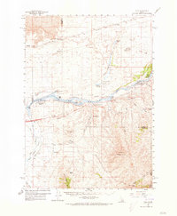
1959 Map of Yale
USGS Topo · Published 1961About this map
Lake Walcott and the Snake River anchor this mid-century landscape where the Minidoka National Wildlife Refuge provides a sanctuary amidst the volcanic terrain of the Lava beds. The map details a transition from the industrial Union Pacific rail corridor through Wapi and DeWoff to the agricultural and ranching operations further south. Family-named landmarks such as the Fenstermaker Ranch, Barkdull Ranch, and Jensen Ranch indicate the scattered settlement patterns typical of this high desert region. Notable for local history is the Minidoka State Picnic Ground (Historical Site) and Register Rock along the river, marking historical transit points. The topography rises sharply from the river valley toward North Canyon Mountain and Badger Peak, where complex drainage systems like Fall Creek and Raft River intersect the rugged volcanic uplands.
Find a feature on this map
56 named features on this map. Tap any name to fly to it.
Don’t see what you’re looking for? This feature index may not catch every label — zoom into the map to look around manually.
Map Details
Editions of this 1959 Yale Map
2 editions found
Other maps of this area

1934 · American Falls
USGS Topo · 1:62,500

1934 · Rockland
USGS Topo · 1:62,500

1936 · American Falls
USGS Topo · 1:62,500

1937 · Rockland
USGS Topo · 1:62,500

1954 · Pocatello
USGS Topo · 1:250,000

1958 · Pocatello
USGS Topo · 1:250,000

1958 · Sublett
USGS Topo · 1:62,500

1959 · Lake Walcott
USGS Topo · 1:62,500

1968 · Malta NE
USGS Topo · 1:24,000
1971 · American Falls SW
USGS Topo · 1:24,000