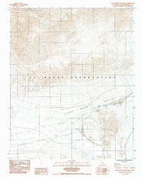
1984 Map of Pilot Knob Valley West
USGS Topo · Published 1984About this map
U S Naval Reservation lands dominate this mid-1980s topographic study of the High Desert, where the rugged peaks of the Slate Range descend toward the floor of the Pilot Knob Valley. The landscape is defined by the sharp verticality of Straw Peak and the isolation of Willow Spring. Evidence of early 20th-century industry persists at the Ruins Mine Shafts, documenting the region's mining heritage in the southeastern corner of the quadrangle. Transportation is strictly limited by the military presence, as evidenced by the Randsburg Road (Restricted) traversing the valley floor. The map offers a precise view of the arid terrain and sparse improvements that characterized this part of San Bernardino County before modern desert management and technological shifts modified the remote basin.
Find a feature on this map
7 named features on this map. Tap any name to fly to it.
Don’t see what you’re looking for? This feature index may not catch every label — zoom into the map to look around manually.
Map Details
Editions of this 1984 Pilot Knob Valley West Map
This is the sole edition of this map. No revisions or reprints were ever made.
Other maps of this area

1915 · Searles Lake
USGS Topo · 1:250,000

1947 · Trona
USGS Topo · 1:250,000

1948 · Trona
USGS Topo · 1:250,000

1949 · Searles Lake
USGS Topo · 1:62,500

1950 · Searles Lake
USGS Topo · 1:62,500

1950 · Wingate Pass
USGS Topo · 1:62,500

1951 · Wingate Pass
USGS Topo · 1:62,500

1953 · Trona
USGS Topo · 1:250,000

1954 · Pilot Knob
USGS Topo · 1:62,500

1954 · Cuddeback Lake
USGS Topo · 1:62,500