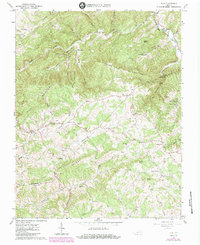
1965 Map of Pilot
USGS Topo · Published 1984About this map
The boundary between Montgomery Co and Floyd Co winds through a high-elevation landscape of deep hollows and prominent summits in the mid-1960s. The South Fork Roanoke River cuts across the northeastern corner, fed by numerous tributaries including Elliott Creek and Beaverdam Creek. Small mountain communities and family-named landmarks are scattered throughout the hills, connected by narrow roads that trace the terrain. The map identifies specific centers of local life like Pilot, Huffville, and Terrys Fork, while religious heritage is visible in the placement of Sowders Chapel, Havens Chapel, and St Mathews Church. High points such as Fishers View Mountain and Coles Knob provide significant relief, overlooking valleys where small cemeteries and creek-side settlements like Tindall and Sugar Grove reflect the rural character of this Appalachian upland.
Find a feature on this map
53 named features on this map. Tap any name to fly to it.
Don’t see what you’re looking for? This feature index may not catch every label — zoom into the map to look around manually.
Map Details
Editions of this 1965 Pilot Map
Other maps of this area

1890 · Christiansburg
USGS Topo · 1:125,000

1932 · Blacksburg
USGS Topo · 1:48,000

1937 · Blacksburg
USGS Topo · 1:62,500

1950 · Elliston
USGS Topo · 1:62,500

1953 · Winston-Salem
USGS Topo · 1:250,000

1955 · Bluefield
USGS Topo · 1:250,000

1955 · Winston-Salem
USGS Topo · 1:250,000

1957 · Endicott
USGS Topo · 1:62,500

1957 · Floyd
USGS Topo · 1:62,500

1957 · Bluefield
USGS Topo · 1:250,000