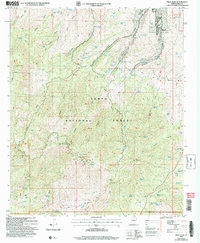
2004 Map of Pinal Peak
USGS Topo · Published 2007About this map
Gila Pueblo Community College and several mobile home communities sit at the northern edge of this high-elevation landscape, where the foothills of the Tonto National Forest meet more developed areas. The map is defined by a dense network of water management features, including dozens of tanks like Old Pond Tank and Twin Tanks, which are critical for supporting both livestock and wildlife in the arid Arizona interior.
Find a feature on this map
99 named features on this map. Tap any name to fly to it.
Don’t see what you’re looking for? This feature index may not catch every label — zoom into the map to look around manually.
Map Details
Editions of this 2004 Pinal Peak Map
This is the sole edition of this map. No revisions or reprints were ever made.
Other maps of this area

1901 · Globe
USGS Topo · 1:62,500

1902 · Globe
USGS Topo · 1:62,500

1910 · Ray
USGS Topo · 1:62,500

1915 · Christmas
USGS Topo · 1:62,500

1917 · Christmas
USGS Topo · 1:62,500

1945 · Globe
USGS Topo · 1:24,000

1945 · Inspiration
USGS Topo · 1:24,000

1947 · Inspiration
USGS Topo · 1:24,000

1948 · Pinal Ranch
USGS Topo · 1:24,000

1949 · Pinal Ranch
USGS Topo · 1:24,000