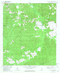
1981 Map of Pine Apple South
USGS Topo · Published 1981About this map
The northern edge of Monroe County and the neighboring portions of Wilcox, Butler, and Conecuh Counties meet in this upland landscape during the early 1980s. The village of Pine Apple serves as a local anchor in the northwest, while the L & N railroad line cuts a diagonal path through the territory, passing near the settlement of Awin. This intersection of rail and rural roads reveals a network of long-established community centers, including Moore Academy and several country churches like Mount Zion Ch and New Hill Ch.
Find a feature on this map
25 named features on this map. Tap any name to fly to it.
Don’t see what you’re looking for? This feature index may not catch every label — zoom into the map to look around manually.
Map Details
Editions of this 1981 Pine Apple South Map
This is the sole edition of this map. No revisions or reprints were ever made.
Other maps of this area

1953 · Andalusia
USGS Topo · 1:250,000

1957 · Andalusia
USGS Topo · 1:250,000

1971 · Skinnerton
USGS Topo · 1:24,000

1971 · Bethel
USGS Topo · 1:24,000

1971 · Georgiana West
USGS Topo · 1:24,000
1981 · Oak Hill
USGS Topo · 1:24,000

1981 · Pine Apple North
USGS Topo · 1:24,000

1981 · Forest Home
USGS Topo · 1:24,000
1981 · Mc Williams
USGS Topo · 1:24,000
1981 · Ridgeville
USGS Topo · 1:24,000