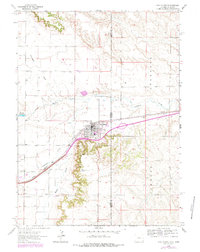
1963 Map of Pine Bluffs
USGS Topo · Published 1984About this map
The town of Pine Bluffs sits as a vital rail and road hub at the eastern edge of Laramie County, straddling the border between Wyoming and Nebraska. This 1963 survey, updated with 1976 aerial revisions, documents the community's dependence on the Union Pacific railroad and the critical corridor of Interstate 80 and U. S. 30. The map reveals a landscape defined by water and infrastructure, from the Wisroth Reservoir and Lodgepole Creek to the town's central Rodeo Ground and local High Sch.
Find a feature on this map
21 named features on this map. Tap any name to fly to it.
Don’t see what you’re looking for? This feature index may not catch every label — zoom into the map to look around manually.
Map Details
Editions of this 1963 Pine Bluffs Map
3 editions found
Other maps of this area

1954 · Scottsbluff
USGS Topo · 1:250,000

1954 · Cheyenne
USGS Topo · 1:250,000

1958 · Cheyenne
USGS Topo · 1:250,000

1958 · Scottsbluff
USGS Topo · 1:250,000

1963 · Pine Bluffs
USGS Topo · 1:24,000

1963 · Lindbergh
USGS Topo · 1:24,000

1963 · Pine Bluffs SE
USGS Topo · 1:24,000

1963 · Pine Bluffs SW
USGS Topo · 1:24,000

1963 · Tracy
USGS Topo · 1:24,000

1968 · Pine Bluffs
USGS Topo · 1:24,000