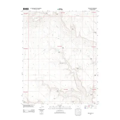
2013 Map of Pine Canyon
USGS Topo · Published 2013About this map
Mesa de Maya dominates the northern landscape of this Las Animas County quadrangle, where a complex network of drainage systems like Pine Canyon and Pacheco Canyon carve through the high plains terrain. This 2013 U.S. Geological Survey record reveals a sparse ranching and agricultural landscape defined by remote water sources and family-named landmarks. The presence of Crespin Cem and the settlement at Lone Oak suggest a history of small communities and homesteads that relied on scattered water points such as Hart Spring and Wilcox Spring. Evidence of local education history persists in the naming of Schoolhouse Canyon, while geographic bottlenecks like The Narrows and prominent elevations such as Hardesty Mesa dictate the winding paths of rural routes like CO Road 10. The map serves as a detailed guide to the land's hydrology, from the seasonal flow of Chacuaco Cr to the hidden alcoves of Gotera Rincon.
Find a feature on this map
35 named features on this map. Tap any name to fly to it.
Don’t see what you’re looking for? This feature index may not catch every label — zoom into the map to look around manually.
Map Details
Editions of this 2013 Pine Canyon Map
This is the sole edition of this map. No revisions or reprints were ever made.
Other maps of this area

1891 · Mesa De Maya
USGS Topo · 1:125,000

1893 · Mesa de Maya
USGS Topo · 1:125,000

1954 · Dalhart
USGS Topo · 1:250,000

1955 · La Junta
USGS Topo · 1:250,000

1958 · La Junta
USGS Topo · 1:250,000

1958 · Dalhart
USGS Topo · 1:250,000

1962 · Dalhart
USGS Topo · 1:250,000

1968 · La Junta
USGS Topo · 1:250,000
1972 · Branson SE
USGS Topo · 1:24,000

1972 · Emery Peak
USGS Topo · 1:24,000