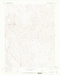
1967 Map of Pine Cone Knob
USGS Topo · Published 1969About this map
Rio Grande National Forest dominates this landscape along the boundary between Saguache and Rio Grande counties, where high-altitude ranching and timber interests shaped the early 20th-century economy. The presence of La Garita Cow Camp and the La Garita Stock Driveway indicates the importance of seasonal grazing in these uplands. Topographic highlights include Cyclone Mountain and the distinct Pine Cone Knob, with numerous drainages like Embargo Creek and Baughman Creek carving through the terrain. Small-scale industrial activity is evidenced by scattered Mines north of the mountain, while recreation appears at Cathedral Campground near the dramatic Cathedral Rock. A network of pack trails and jeep trails provides insight into the accessibility of this mountainous interior during the late 1960s.
Find a feature on this map
29 named features on this map. Tap any name to fly to it.
Don’t see what you’re looking for? This feature index may not catch every label — zoom into the map to look around manually.
Map Details
Editions of this 1967 Pine Cone Knob Map
2 editions found
Other maps of this area

1914 · Creede
USGS Topo · 1:125,000

1915 · Del Norte
USGS Topo · 1:125,000

1916 · Creede
USGS Topo · 1:125,000

1917 · Del Norte
USGS Topo · 1:125,000

1945 · Durango
USGS Topo · 1:250,000

1953 · Durango
USGS Topo · 1:250,000

1954 · Durango
USGS Topo · 1:250,000

1961 · Durango
USGS Topo · 1:250,000

1963 · Durango
USGS Topo · 1:250,000

1966 · Durango
USGS Topo · 1:250,000