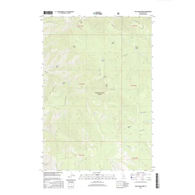
2017 Map of Pine Creek Ridge
USGS Topo · Published 2017About this map
Salmon National Forest dominates this interior portion of Lemhi County, defined by a series of steep drainages and prominent summits. The landscape is marked by a complex network of named ravines, including Sawmill Gulch, Sawlog Gulch, and China Gulch, which suggest historical wood-processing and prospecting activities. High-elevation landmarks like Stormy Peak and Haystack Mtn provide the primary orientation points for the area, while the central Pine Creek Ridge divides the primary watercourses. This map documents a high-country environment where narrow forest roads such as the Stormy Pk-Virginia and China Gulch Rd follow the natural contours of the land. Seasonal hydrological features like Swampy Meadows and East Boulder Meadow indicate areas of flatter, moisture-retaining terrain amidst the steep slopes of Hornet Creek and Beaver Cr.
Find a feature on this map
36 named features on this map. Tap any name to fly to it.
Don’t see what you’re looking for? This feature index may not catch every label — zoom into the map to look around manually.
Map Details
Editions of this 2017 Pine Creek Ridge Map
This is the sole edition of this map. No revisions or reprints were ever made.
Other maps of this area

1950 · Blackbird Mtn
USGS Topo · 1:62,500

1950 · Leesburg
USGS Topo · 1:62,500

1951 · Leesburg
USGS Topo · 1:62,500

1951 · Blackbird Mtn
USGS Topo · 1:62,500

1956 · Elk City
USGS Topo · 1:250,000

1960 · Elk City
USGS Topo · 1:250,000

1960 · Ulysses Mtn
USGS Topo · 1:62,500

1960 · Shoup
USGS Topo · 1:62,500

1982 · Bighorn Crags
USGS Topo · 1:100,000
1989 · Leesburg
USGS Topo · 1:24,000