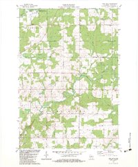
1982 Map of Pine Dells
USGS Topo · Published 1983About this map
The Prairie River and Pine River carve through this section of Lincoln County, defining a landscape where public lands and rural community life intersect. In the north, the Prairie River State Public Hunting Grounds occupies a significant portion of the terrain near Merrill and Schley. The map documents a well-distributed network of local heritage sites, including several religious centers and burial grounds such as Trinity Cem, St James Cem, and Calvary Ch. Small-scale industrial activity is evident in the numerous Gravel Pits scattered across the township, while the winding courses of Barnes Creek and Little Trappe River suggest the drainage patterns that have historically shaped local agriculture and land use in this part of Wisconsin.
Find a feature on this map
42 named features on this map. Tap any name to fly to it.
Don’t see what you’re looking for? This feature index may not catch every label — zoom into the map to look around manually.
Map Details
Editions of this 1982 Pine Dells Map
This is the sole edition of this map. No revisions or reprints were ever made.
Other maps of this area

1899 · Wausau
USGS Topo · 1:125,000

1902 · Wausau
USGS Topo · 1:125,000

1940 · Parrish
USGS Topo · 1:48,000

1950 · Parrish
USGS Topo · 1:48,000

1950 · Tomahawk
USGS Topo · 1:48,000

1951 · Doering
USGS Topo · 1:48,000

1951 · Merrill
USGS Topo · 1:48,000

1952 · Parrish
USGS Topo · 1:48,000

1952 · Tomahawk
USGS Topo · 1:48,000

1954 · Iron Mountain
USGS Topo · 1:250,000