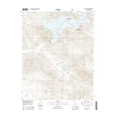
2015 Map of Pine Flat Dam
USGS Topo · Published 2015About this map
Pine Flat Dam anchors this transition between the Central Valley floor and the high peaks of the Sierra Nevada. This 2015 update shows the engineered shoreline of Pine Flat Lake where it meets the Kings River, carving through steep terrain marked by Granite Ridge and Hughes Mtn. The landscape is a mix of public and private use, with the Sierra National Forest and Sequoia National Forest bordering the reservoir's eastern reaches. Settlement patterns vary from the residential clusters in Wonder Valley to the more dispersed topography of Clark Valley. Local history is preserved at the Hughes Creek Cem near the northern boundary, while numerous seasonal watercourses like Russian Charley Cr and Zebe Cr illustrate the complex drainage system feeding the dam. Detailed road labels, including Trimmer Springs Rd and N Crawford Ave, provide precise navigation for modern explorers of these foothills.
Find a feature on this map
49 named features on this map. Tap any name to fly to it.
Don’t see what you’re looking for? This feature index may not catch every label — zoom into the map to look around manually.
Map Details
Editions of this 2015 Pine Flat Dam Map
This is the sole edition of this map. No revisions or reprints were ever made.
Other maps of this area

1920 · Orangedale School
USGS Topo · 1:24,000

1921 · Squaw Valley
USGS Topo · 1:31,680

1922 · Trimmer
USGS Topo · 1:96,000

1923 · Orangedale School
USGS Topo · 1:31,680

1923 · Wahtoke
USGS Topo · 1:31,680

1924 · Citrus Cove
USGS Topo · 1:31,680

1924 · Dinuba
USGS Topo · 1:125,000

1942 · Watts Valley
USGS Topo · 1:62,500

1942 · Dunlap
USGS Topo · 1:62,500

1944 · Watts Valley
USGS Topo · 1:62,500