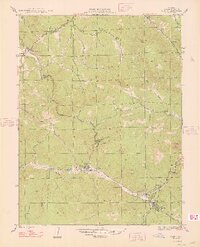
1948 Map of Pine
USGS Topo · Published 1948About this map
The North Fork Platte River and South Fork Platte River converge within this mid-century mountain landscape, centering on the settlement of Pine. The region's transition from a ranching frontier to a recreational corridor is evident through landmarks like Z Bar D Ranch and Clise Ranch alongside specialized mountain developments such as Sphinx Park. Local life is anchored by the Elk Creek Sch and a small Cem near the riverbanks. High altitude terrain is defined by prominent peaks including Riley Peak, Banner Peak, and the Cathedral Spires. Notable water features like Crystal Lake and the winding Gooseberry Gulch feed into the primary river system, reflecting the hydrologic importance of the area managed by the Denver Board of Water Commissioners.
Find a feature on this map
39 named features on this map. Tap any name to fly to it.
Don’t see what you’re looking for? This feature index may not catch every label — zoom into the map to look around manually.
Map Details
Editions of this 1948 Pine Map
2 editions found
Other maps of this area

1893 · Platte Canyon
USGS Topo · 1:125,000

1899 · West Denver
USGS Topo · 1:125,000

1945 · Indian Hills
USGS Topo · 1:31,680

1945 · Platte Canyon
USGS Topo · 1:24,000

1945 · Pine
USGS Topo · 1:24,000

1945 · Bailey
USGS Topo · 1:24,000

1948 · Pine
USGS Topo · 1:24,000

1948 · Platte Canyon
USGS Topo · 1:24,000

1949 · Bailey
USGS Topo · 1:24,000

1953 · Denver
USGS Topo · 1:250,000