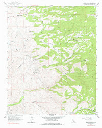
1965 Map of Pine Mountain
USGS Topo · Published 1977About this map
Granite Station serves as the primary landmark in this mid-1960s survey of the California foothills, where the landscape transitions from open flats to more complex drainage networks. The map documents an economy driven by resource extraction, clearly marking the Round Mountain Oil Field in the southwest and several hard-rock operations including the Long Tom Mine and Poso Mine. The rugged character of the area is defined by the winding course of Poso Creek and its many tributaries, such as Grimaud Creek and Five Dog Creek, which cut through the terrain toward Poso Flat. This edition captures the infrastructure of the era, from the winding Granite Road to the high-elevation Radio Towers, while also preserving small details for local historians such as a remote cemetery and numerous spring-fed water sources scattered across the slopes of Pine Mountain.
Find a feature on this map
29 named features on this map. Tap any name to fly to it.
Don’t see what you’re looking for? This feature index may not catch every label — zoom into the map to look around manually.
Map Details
Editions of this 1965 Pine Mountain Map
2 editions found
Other maps of this area

1906 · Bakersfield
USGS Topo · 1:62,500

1914 · Caliente
USGS Topo · 1:125,000

1920 · Delonagha
USGS Topo · 1:62,500

1926 · Glennville
USGS Topo · 1:62,500

1932 · Woody
USGS Topo · 1:62,500
1933 · Oil Center
USGS Topo · 1:31,680

1935 · Woody
USGS Topo · 1:62,500

1936 · Tobias Peak
USGS Topo · 1:125,000
1940 · Oil Center
USGS Topo · 1:31,680

1943 · Breckenridge Mountain
USGS Topo · 1:62,500