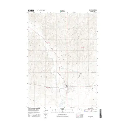
2015 Map of Pine Ridge
USGS Topo · Published 2015About this map
Pine Ridge serves as the primary hub of this landscape, situated at a junction of creek valleys and modern transit routes. The settlement's infrastructure includes the Pine Ridge Airport to the east and the Holy Cross Cem near the town center. The surrounding terrain is defined by a dendritic drainage network, with White Clay Cr and Wolf Cr converging near the community. A series of specialized rural routes, such as Merrival Buffalo Ranch Rd and Old Wolf Cr Sch Back Rd, suggest a landscape shaped by ranching and local educational access. The map reveals the intricate intersection of land management and natural waterways like Cheyenne Cr and Herd Camp Cr on the high plains.
Find a feature on this map
23 named features on this map. Tap any name to fly to it.
Don’t see what you’re looking for? This feature index may not catch every label — zoom into the map to look around manually.
Map Details
Editions of this 2015 Pine Ridge Map
This is the sole edition of this map. No revisions or reprints were ever made.
Other maps of this area

1955 · Hot Springs
USGS Topo · 1:250,000

1955 · Alliance
USGS Topo · 1:250,000

1957 · Alliance
USGS Topo · 1:250,000

1958 · Alliance
USGS Topo · 1:250,000

1967 · Pine Ridge SW
USGS Topo · 1:24,000

1967 · Pine Ridge NE
USGS Topo · 1:24,000

1967 · Pine Ridge
USGS Topo · 1:24,000

1967 · Manderson
USGS Topo · 1:24,000

1967 · Oglala
USGS Topo · 1:24,000

1967 · Manderson SW
USGS Topo · 1:24,000