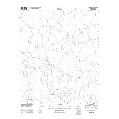
2011 Map of Pinedale
USGS Topo · Published 2011About this map
Pinedale and Burton anchor this high-desert landscape in the early twenty-first century, showing a pattern of settlement and water management characteristic of the Mogollon Rim country. The map documents a complex system of livestock tanks such as Thistle Tank, Railroad Tank, and Brittenham Tank, reflecting the area's ongoing reliance on seasonal runoff captured in local washes. Dramatic relief is marked by Juniper Ridge, topped by the Juniper Ridge Lookout Tower, while deep erosional features like Lewis Canyon and Danish Hollow segment the terrain. Transportation is defined by a mix of established routes like Pinedale Rd and a dense network of forest service and local tracks including Old Settler Trl and Timberland Rd. Near Turkey Lake, the landscape remains relatively open, punctuated by family-named landmarks like Owens Tank and Malone Tank that offer clues to the region's ranching history.
Find a feature on this map
91 named features on this map. Tap any name to fly to it.
Don’t see what you’re looking for? This feature index may not catch every label — zoom into the map to look around manually.
Map Details
Editions of this 2011 Pinedale Map
This is the sole edition of this map. No revisions or reprints were ever made.
Other maps of this area

1886 · Holbrook
USGS Topo · 1:250,000

1893 · Holbrook
USGS Topo · 1:250,000

1954 · Holbrook
USGS Topo · 1:250,000

1957 · Holbrook
USGS Topo · 1:250,000

1958 · Holbrook
USGS Topo · 1:250,000

1960 · Holbrook
USGS Topo · 1:250,000

1961 · Clay Springs
USGS Topo · 1:62,500
1961 · Show Low
USGS Topo · 1:62,500

1961 · Cibecue
USGS Topo · 1:62,500
1970 · Cactus Flat
USGS Topo · 1:24,000