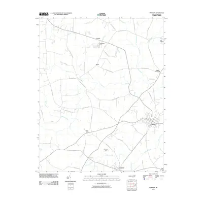
2010 Map of Pinetops
USGS Topo · Published 2010About this map
Town Creek and its various tributaries, including Williamson Branch and Bynum Mill Creek, create a branching drainage pattern across this Edgecombe County landscape. The road network connects a series of small rural communities and named intersections, such as Lancaster, Mercer, and Pitt Crossroads, which serve as local anchors between larger settlements. The town of Pinetops stands out with its distinct grid of residential streets, while Macclesfield anchors the southern portion of the sheet near Bynums Mill Run.
Find a feature on this map
45 named features on this map. Tap any name to fly to it.
Don’t see what you’re looking for? This feature index may not catch every label — zoom into the map to look around manually.
Map Details
Editions of this 2010 Pinetops Map
This is the sole edition of this map. No revisions or reprints were ever made.
Other maps of this area

1902 · Rocky Mount
USGS Topo · 1:62,500
1902 · Tarboro
USGS Topo · 1:62,500
1903 · Tarboro
USGS Topo · 1:62,500
1904 · Falkland
USGS Topo · 1:62,500

1904 · Rocky Mount
USGS Topo · 1:62,500
1904 · Wilson
USGS Topo · 1:62,500

1953 · Rocky Mount
USGS Topo · 1:250,000

1954 · Rocky Mount
USGS Topo · 1:250,000

1975 · Rocky Mount
USGS Topo · 1:24,000
1977 · Rocky Mount
USGS Topo · 1:24,000