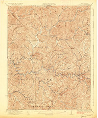
1927 Map of Pineville
USGS Topo · Published 1927About this map
The Guyandot River winds through this 1920s topography of Wyoming County, where deep valleys and prominent ridges defined the limits of settlement. Pineville serves as a primary hub along the river, connected to outlying communities like Baileysville and Oceana by a network of valley roads. The landscape is heavily marked by the timber industry's reach, evidenced by the Lumber RR snaking through the eastern hollows near Glen Morrison and the Virginian RR following the river corridor. A high density of rural schoolhouses, such as the Dingess School, Bradley School, and Adkin School, reveals a dispersed but organized social fabric where small coal and lumber settlements were tucked into almost every major creek branch including Huff Creek and Clear Fork.
Find a feature on this map
129 named features on this map. Tap any name to fly to it.
Don’t see what you’re looking for? This feature index may not catch every label — zoom into the map to look around manually.
Map Details
Editions of this 1927 Pineville Map
2 editions found
Other maps of this area

1887 · Pocahontas
USGS Topo · 1:125,000

1891 · Tazewell
USGS Topo · 1:125,000

1891 · Pocahontas
USGS Topo · 1:125,000

1891 · Oceana
USGS Topo · 1:125,000

1891 · Raleigh
USGS Topo · 1:125,000

1893 · Oceana
USGS Topo · 1:125,000

1894 · Pocahontas
USGS Topo · 1:125,000

1895 · Tazewell
USGS Topo · 1:125,000

1895 · Pocahontas
USGS Topo · 1:125,000

1897 · Tazewell
USGS Topo · 1:125,000