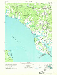
1953 Map of Piney Point
USGS Topo · Published 1953About this map
The Potomac River dominates the western shoreline of this mid-century survey, which details the peninsula between the river and St Marys River. The area is defined by its maritime infrastructure, featuring the Piney Point Lighthouse and the Ragged Point Lighthouse offshore. Inland, the settlement patterns of Valley Lee and Chingville are established alongside numerous creek systems like Herring Creek and Blake Creek. Local community life is anchored by landmarks such as St Georges Ch and the Tall Timbers PO. The map also captures significant military and aviation footprints of the era, including a Naval Reservation at Piney Point and an Emergency Landing Field near the coast. This coastal geography shows a landscape of named points and coves, from McKay Cove to Piney Point Beach, reflecting a region deeply tied to its waterways and the defense of the Chesapeake approaches.
Find a feature on this map
75 named features on this map. Tap any name to fly to it.
Don’t see what you’re looking for? This feature index may not catch every label — zoom into the map to look around manually.
Map Details
Editions of this 1953 Piney Point Map
2 editions found
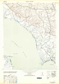
Other maps of this area

1892 · Leonardtown
USGS Topo · 1:62,500

1892 · Drum Point
USGS Topo · 1:62,500

1892 · Piney Point
USGS Topo · 1:62,500

1894 · Piney Point
USGS Topo · 1:62,500

1894 · Point Lookout
USGS Topo · 1:62,500

1895 · Leonardtown
USGS Topo · 1:62,500

1895 · Nomini
USGS Topo · 1:125,000

1895 · Piney Point
USGS Topo · 1:62,500

1898 · Nomini
USGS Topo · 1:125,000

1898 · St. Marys
USGS Topo · 1:125,000