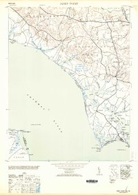
1953 Map of Piney Point
USGS Topo · Published 1953About this map
The Southern Maryland shoreline along the Potomac River defines this 1953 survey, which depicts the intricate coastal landscape of St. Mary's County just after the Second World War. Maritime navigation is central to the area's geography, marked by the Piney Point Lighthouse and the St George Island Light 1 at the entrance to St George Harbor. Inland, the landscape is a network of tobacco-growing districts like Leonardtown No 3 and Valley Lee No 2, connected by small settlements such as Valley Lee and Chingville. The map documents a period of strategic military and logistical utility, featuring a Naval Reservation near Piney Point and an Emergency Landing Field tucked between Herring Creek and the river. Genealogists will find value in the named coves and points, such as Albright Pt and Sheehan Pt, which often reflect local family landholdings.
Find a feature on this map
66 named features on this map. Tap any name to fly to it.
Don’t see what you’re looking for? This feature index may not catch every label — zoom into the map to look around manually.
Map Details
Editions of this 1953 Piney Point Map
2 editions found
Other maps of this area

1892 · Leonardtown
USGS Topo · 1:62,500

1892 · Drum Point
USGS Topo · 1:62,500

1892 · Piney Point
USGS Topo · 1:62,500

1894 · Piney Point
USGS Topo · 1:62,500

1894 · Point Lookout
USGS Topo · 1:62,500

1895 · Leonardtown
USGS Topo · 1:62,500

1895 · Nomini
USGS Topo · 1:125,000

1895 · Piney Point
USGS Topo · 1:62,500

1898 · Nomini
USGS Topo · 1:125,000

1898 · St. Marys
USGS Topo · 1:125,000