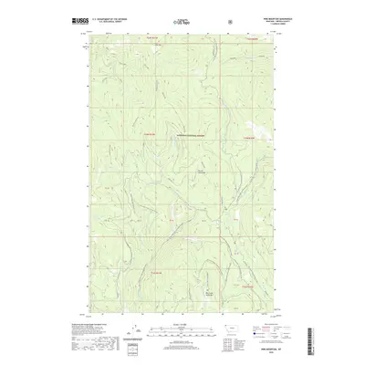
2020 Map of Pink Mountain
USGS Topo · Published 2020About this map
The high ridges of the Purcell Mountains define this section of the Kootenai National Forest, where steep drainages and mountain peaks dominate the landscape. Named summits like Pink Mtn and Big Creek Baldy Mtn provide the primary vertical landmarks, while the Pipe Divide serves as a geographic spine through the center of the quadrangle. The map documents a complex system of drainage basins, including Zulu Creek, Smoot Cr, and Bearfite Cr, which carve out the deep valleys below the timberline.
Find a feature on this map
38 named features on this map. Tap any name to fly to it.
Don’t see what you’re looking for? This feature index may not catch every label — zoom into the map to look around manually.
Map Details
Editions of this 2020 Pink Mountain Map
This is the sole edition of this map. No revisions or reprints were ever made.
Other maps of this area

1957 · Kalispell
USGS Topo · 1:250,000

1960 · Kalispell
USGS Topo · 1:250,000

1961 · Kalispell
USGS Topo · 1:250,000

1963 · Yaak
USGS Topo · 1:24,000

1963 · Turner Mountain
USGS Topo · 1:24,000

1963 · Pink Mountain
USGS Topo · 1:24,000

1963 · Banfield Mountain
USGS Topo · 1:24,000

1963 · Boulder Lakes
USGS Topo · 1:24,000
1963 · Flatiron Mountain
USGS Topo · 1:24,000

1963 · Lost Horse Mountain
USGS Topo · 1:24,000