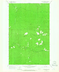
1963 Map of Banfield Mountain
USGS Topo · Published 1966About this map
Kootenai National Forest dominates this mountain landscape, defined by steep drainages and summit lookouts. The summit of Banfield Mountain serves as a primary landmark, featuring a charted Lookout Tower that overlooked the surrounding timber stands and watersheds in the early 1960s. The terrain is divided by several significant water systems, including the headwaters of Blue Creek which flows near Blue Lake, and the winding Barron Creek in the southern reaches.
Find a feature on this map
21 named features on this map. Tap any name to fly to it.
Don’t see what you’re looking for? This feature index may not catch every label — zoom into the map to look around manually.
Map Details
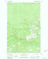
Editions of this 1963 Banfield Mountain Map
2 editions found
Other maps of this area

1920 · Libby
USGS Topo · 1:125,000

1920 · Jennings
USGS Topo · 1:125,000

1930 · Libby
USGS Topo · 1:125,000
1932 · Libby
USGS Topo · 1:125,000

1935 · Thompson Lakes
USGS Topo · 1:96,000

1942 · Thompson Lakes
USGS Topo · 1:125,000

1957 · Kalispell
USGS Topo · 1:250,000

1960 · Kalispell
USGS Topo · 1:250,000

1961 · Kalispell
USGS Topo · 1:250,000
1963 · Vermiculite Mountain
USGS Topo · 1:24,000