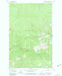
1963 Map of Banfield Mountain
USGS Topo · Published 1984About this map
Kootenai National Forest dominates this topographic survey, revealing a landscape defined by sharp elevation changes and deep drainages. The terrain is centered on Banfield Mountain, where a Lookout Tower once served as a critical vantage point for forest management. This 1963 survey, later updated with photorevisions in the early 1980s, captures the intricate network of pack trails and watercourses that shaped local access before modern road development became widespread. To the north, Lost Soul Mountain and Lawrence Mountain stand as prominent landmarks above the South Fork Big Creek. The map documents a transition in wilderness utility, from the traditional navigation of a Pack Trail to the introduction of a Spring Road. Remote water features like Blue Lake and the various forks of Bristow Creek highlight the drainage patterns of the Purcell Mountains within this section of Lincoln County.
Find a feature on this map
21 named features on this map. Tap any name to fly to it.
Don’t see what you’re looking for? This feature index may not catch every label — zoom into the map to look around manually.
Map Details
Editions of this 1963 Banfield Mountain Map
2 editions found

Other maps of this area

1920 · Libby
USGS Topo · 1:125,000

1920 · Jennings
USGS Topo · 1:125,000

1930 · Libby
USGS Topo · 1:125,000

1932 · Libby
USGS Topo · 1:125,000

1935 · Thompson Lakes
USGS Topo · 1:96,000

1942 · Thompson Lakes
USGS Topo · 1:125,000

1957 · Kalispell
USGS Topo · 1:250,000

1960 · Kalispell
USGS Topo · 1:250,000

1961 · Kalispell
USGS Topo · 1:250,000

1963 · Vermiculite Mountain
USGS Topo · 1:24,000